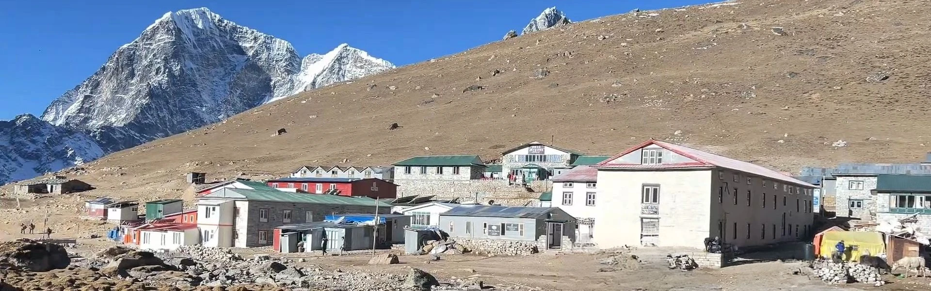
Lobuche Village, Nepal, sits at 4,940 metres in the Everest region, serving as one of the last settlements before reaching Everest Base Camp. This high-altitude village exists purely to support trekkers and mountaineers pushing toward higher altitudes. Understanding what Lobuche offers, and what it lacks, shapes realistic expectations for anyone planning the Everest Base Camp trek.
Most trekkerspass through Lobuche during their journey, either staying one night or using it as an acclimatisation stop. The village altitude tests physical limits, weather conditions change rapidly, and comfort levels drop significantly compared to lower stops like Namche Bazaar or Dingboche. Yet Lobuche remains essential for safe altitude progression and proper preparation before reaching Gorak Shep.
This guide by Nepal Everest Base Camp Co. covers everything practical about Lobuche Village, Nepal, from exact location and trek routes to accommodation in Lobuche, seasonal weather patterns, and climbing opportunities on Lobuche Peak. Whether you are a first-time high-altitude trekker or planning to climb Lobuche East, you will find grounded information that helps you prepare properly and trek safely through this demanding section of the Khumbu region.
Where Is Lobuche Village Located?
Lobuche village is positioned in the Khumbu region of Nepal, sitting on the western side of the Khumbu Glacier moraine. Moreover, the village is located approximately 8.5 kilometres southwest of Everest Base Camp and falls within Sagarmatha National Park boundaries. Geographically, Lobuche occupies a glacial valley surrounded by towering peaks in the Everest region, including Mount Everest, Nuptse, and Pumori.
Consequently, the small village divides into two parts:
Lower Lobuche at approximately 4,910 meters
Upper Lobuche at roughly 4,940 meters
Both sections function as trekking stops, though most lodges cluster around the upper area. Furthermore, the location of Lobuche places it directly on the standard route to Everest Base Camp, making it unavoidable for anyone heading toward the world's highest mountain.
Elevation at Lobuche reaches 4,940 metres (16,207 feet) above sea level. As a result, this elevation places it firmly in the high altitude category, where oxygen levels drop to approximately 53% of sea-level availability. Consequently, your body works significantly harder to perform basic functions. Breathing becomes noticeably more laboured, sleep quality decreases, and physical exertion feels more demanding.
Additionally, the village in the Everest region plays a critical role on the Everest Base Camp trekking route because it sits at the threshold where altitude sickness becomes a serious concern for many trekkers. Moreover, the altitude makes Lobuche an ideal staging point for those attempting Lobuche East Peak (6,119 m) or Lobuche West Peak (6,145 m).
Lobuche functions as a critical waypoint on the standard Everest Base Camp trail. Generally, most trekkers arrive here on Day 8 or 9 of their itinerary, having already acclimatised at Namche Bazaar and Dingboche. In fact, the village represents the final substantial settlement before Gorak Shep, which offers even more basic facilities.
From Dingboche, trekkers typically walk 5-6 hours to reach Lobuche, crossing Thukla Pass (4,830 m) and the Everest Memorial commemorating climbers who lost their lives on Everest. Subsequently, from Lobuche, the trail continues northeast toward Gorak Shep, then splits into two options. One route leads to Everest Base Camp; the other climbs to Kala Patthar viewpoint.
Location
Distance from Lobuche
Walking Time
Dingboche
7.5 km south
5-6 hours uphill
Gorak Shep
3.4 km northeast
2-3 hours
Everest Base Camp
8.5 km northeast
5-6 hours (via Gorak Shep)
Kala Patthar
5.2 km northeast
4-5 hours (via Gorak Shep)
Note: Distances shown reflect the trekking path, not straight-line measurements. Terrain includes rocky moraine, gradual ascents, and exposed sections subject to wind and weather changes.
How to Reach Lobuche Village
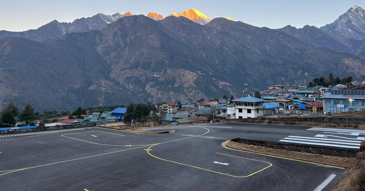
The standard approach to get to Lobuche begins with a flight from Kathmandu to Lukla (2,860 m). Subsequently, from Lukla, trekkers follow the well-established trail to Everest, gradually gaining altitude through Sherpa villages, suspension bridges, and alpine terrain. Overall, reaching Lobuche requires 7-9 days of walking, depending on your itinerary and acclimatisation schedule.
Namche Bazaar (acclimatisation day): Rest or short hike
Namche to Tengboche: 5-6 hours, moderate terrain
Tengboche to Dingboche: 5-6 hours, gradual ascent
Dingboche (acclimatisation day): Rest or hike to Nangkartshang
Dingboche to Lobuche: 5-6 hours, crossing Thukla Pass
Importantly, this progression allows your body to adjust gradually. In contrast, skipping acclimatisation days increases the risk of altitude sickness and reduces your chances of completing the trek successfully.
After leaving Dingboche, the trail climbs steadily toward Thukla, a small mountain village with a few teahouses. Beyond Thukla, trekkers face a steep ascent to Thukla Pass, also known as Dugla Pass. At the top sits the Everest Memorial, a collection of stone cairns honouring climbers and Sherpas who died on Everest and surrounding peaks.
The memorial serves as a sobering reminder of the risks involved in high-altitude mountaineering. Consequently, many trekkers pause here to reflect before continuing. From the pass, the trail levels out across rocky moraine terrain, eventually reaching Lobuche after another 1-2 hours of walking. Notably, the landscape becomes increasingly barren, with sparse vegetation and glacial debris dominating the surroundings.
Trail Section
Elevation Gain
Terrain Type
Dingboche to Thukla
+230m
Gradual ascent
Thukla to Thukla Pass
+200m
Steep switchbacks
Thukla Pass to Lobuche
+140m
Rocky moraine
While the standard route from Lukla remains the most common, alternative approaches exist for experienced trekkers. For instance, the Everest Three Passtrek includes Lobuche as part of a longer circuit crossing Kongma La, Cho La, and Renjo La passes. However, this route offers more challenging terrain and greater solitude but requires additional time and fitness.
Furthermore, another option involves trekking from Jiri or Salleri, traditional starting points before the Lukla airstrip opened. These routes add 5-7 days to your itinerary but provide a more gradual altitude gain and deeper cultural immersion. Nevertheless, most trekkers prioritise efficiency and choose the Lukla route.
All trekkers heading to Lobuche must obtain two permits:
Sagarmatha National Park Entry Permit: NPR 3,000 (approximately USD 23) for foreign nationals
Both permits can be arranged in Kathmandu or purchased upon arrival in Monjo, the Sagarmatha National Park entrance checkpoint. Additionally, if you plan to climb Lobuche Peak, you need a separate climbing permit issued by the Nepal Mountaineering Association (NMA).
East Peak falls under the NMA’s trekking peak category and requires a permit costing USD 250 to USD 400, depending on the season. A licensed climbing guide is mandatory for Peak climbing, as per NMA regulations, to ensure safety, proper rope fixing, and compliance with mountaineering rules.
Best Time to Visit Lobuche Village
Weather patterns at Lobuche follow the same seasonal cycles as the broader Everest region of Nepal. Generally, the best time to visit Lobuche aligns with the two main trekking seasons, spring (March to May) and autumn (September to November). These periods offer the most stable weather, clearer skies, and safer trekking conditions.
Lobuche weather remains harsh year-round due to the elevation. Even during favourable seasons, temperatures drop well below freezing at night, winds can be fierce, and sudden weather changes occur without warning. Therefore, understanding what each season brings helps you prepare properly and set realistic expectations.
Longer daylight hours and progressively rising temperatures are hallmarks of spring. Typically, daytime temperatures range from -5°C to 10°C, while nighttime lows drop to -15°C or colder. Additionally, snow from winter begins to melt, though patches remain on trails and surrounding slopes.
Key spring characteristics:
Clear mornings with afternoon cloud buildup
Blooming rhododendrons at lower elevations
Increasing trekker numbers as the season progresses
Good visibility for views of Everest and surrounding peaks
Moderate wind conditions compared to winter
March can still feel wintry, especially early in the month. However, April and May offer the warmest conditions, though May afternoons sometimes bring brief showers as the monsoon approaches. Notably, spring also marks the primary Everest summit climbing season, so you may encounter mountaineering expeditions moving through Lobuche.
Autumn provides the most reliable weather for trekking in Nepal. During this season, temperatures range from 0°C to 12°C during the day, dropping to -10°C to -20°C at night. Moreover, the monsoon has cleared the atmosphere, resulting in exceptional visibility and crisp mountain views.
Autumn Month
Daytime Temp
Nighttime Temp
Conditions
September
5°C to 12°C
-5°C to -10°C
Occasional rain early in the month
October
0°C to 10°C
-10°C to -15°C
Peak season, stable weather
November
-5°C to 5°C
-15°C to -20°C
Colder, fewer trekkers
October stands out as the busiest month, with lodges often fully booked. Consequently, reservations become necessary during this period. In contrast, November sees fewer trekkers, colder temperatures, and increased snowfall risk but offers quieter trails and excellent photographic conditions.
Winter trek conditions at Lobuche become significantly more challenging. Specifically, temperatures plummet, with daytime highs barely reaching 0°C and nighttime lows dropping below -20°C. Additionally, snow accumulation increases, and high winds make exposure dangerous.
Winter challenges:
Many lodges close or operate with minimal staff
Limited food options and reduced menu variety
Increased risk of frostbite and hypothermia
Shorter daylight hours for trekking
Higher avalanche risk on surrounding slopes
Despite these difficulties, experienced winter trekkersvisit Lobuche for solitude and pristine snow-covered landscapes. Proper gear, including expedition-grade sleeping bags and insulated clothing, becomes essential. Furthermore, you should carry emergency supplies and be prepared to turn back if conditions worsen.
Monsoon season (June to August) brings heavy rainfall to lower elevations, though Lobuche sits in a rain shadow zone receiving less precipitation. Nonetheless, the season presents significant challenges. Specifically, cloud cover obscures mountain views, trails become muddy and slippery, and landslides occasionally block the route below Namche.
Few trekkersvisit during monsoon, resulting in closed lodges and limited services. The Lobuche region receives some rain and frequent fog, reducing visibility and increasing navigation difficulty. However, valleys below bloom with wildflowers, and the landscape turns surprisingly green, a stark contrast to the barren post-monsoon scenery.
Mountain See from Kalapatther
Accommodation in Lobuche Village
Accommodation in Lobuche consists entirely of basic teahouses and lodges built to withstand extreme high altitude conditions. Expect simple facilities focused on survival and rest rather than comfort. During peak season, the village contains roughly 8-10 operating lodges, though only 3-4 remain open during winter months.
Common lodge features:
Stone or timber construction with corrugated metal roofs
Unheated rooms with twin beds and thin mattresses
Communal dining areas with wood-burning or kerosene stoves
Shared bathroom facilities, often outside the main building
Limited electricity from solar panels or small generators
Room conditions reflect the harsh environment. Walls often lack insulation, windows may not seal properly, and frost forms inside during winter nights. Most trekkers sleep fully clothed in their sleeping bags to stay warm. Therefore, bringing a four-season sleeping bag rated to at least -15°C is strongly recommended.
Lodges provide blankets, but their warmth and cleanliness vary. Relying solely on provided bedding rarely proves sufficient at this elevation. The cold penetrates deeply, and sleeping becomes difficult without proper insulation. Consequently, heating exists only in communal dining areas, where trekkers gather around stoves burning yak dung or wood.
These rooms offer the only warmth available, making them social hubs where people share stories, play cards, and escape the cold. However, smoke and carbon monoxide can accumulate, so ventilation remains important. Meanwhile, food options follow standard teahouse menus found throughout the Khumbu region.
Expect dal bhat (lentil soup with rice), fried rice, noodle soups, momos (dumplings), and simple pasta dishes. Western items like pancakes, toast, and eggs appear on menus but often come with limited availability.
Typical menu items:
Dal bhat thal (unlimited refills)
Sherpa stew
Fried noodles or rice
Garlic soup (popular for altitude sickness prevention)
Instant noodles
Tea, coffee, hot chocolate
Food quality and variety decrease compared to lower elevations. Fresh vegetables become scarce, and everything arrives via porter or yak, increasing costs. Additionally, meals take longer to cook due to reduced boiling temperatures at high altitude. In fact, water boils at approximately 84°C at Lobuche, slowing cooking times significantly.
Facilities in Lobuche remain minimal. Charging electronic devices costs NPR 300-500 per hour, as lodges rely on limited solar power. Therefore, bring portable battery packs to reduce dependency on lodge electricity. Hot showers exist in some lodges but cost NPR 500-700 and use water heated over stoves, not continuous hot water systems.
Internet access comes through Everest Link or Ncell wifi, costing NPR 500-1,000 for limited data packages. Connections remain slow and unreliable, often dropping during peak usage times. Similarly, mobile phone signals work sporadically with Ncell or NTC SIM cards, but coverage remains inconsistent.
Service
Typical Cost (NPR)
Notes
Room (per night)
500-1,000
Free if eating meals at lodge
Dal bhat
800-1,200
Includes refills
Fried rice/noodles
600-1,000
Smaller portions than lower villages
Hot shower
500-700
Often limited hot water
Battery charging
300-500/hour
Limited solar power
Wifi access
500-1,000
Slow, unreliable connection
Costs increase with altitude. Everything at Lobuche costs roughly 30-50% more than Namche Bazaar. This reflects the difficulty of transporting supplies and the reduced competition among lodge owners. Consequently, booking ahead during October becomes necessary, as lodges fill quickly.
During other months, walking in usually works fine. Lodge quality varies, but overall standards remain similar across all properties. Therefore, choosing a lodge often depends on availability rather than specific amenities. Notably, the accommodations at Lobuche village are simple but functional for the purpose they serve.
Daily Life and Local Environment in Lobuche
Lobuche is a small settlement with no permanent year-round population. The village exists solely to serve the trekking and mountaineering industry. During peak seasons, 30-50 people may be present, mostly lodge owners, staff, and porters. In winter, this drops to perhaps 5-10 individuals maintaining skeleton operations.
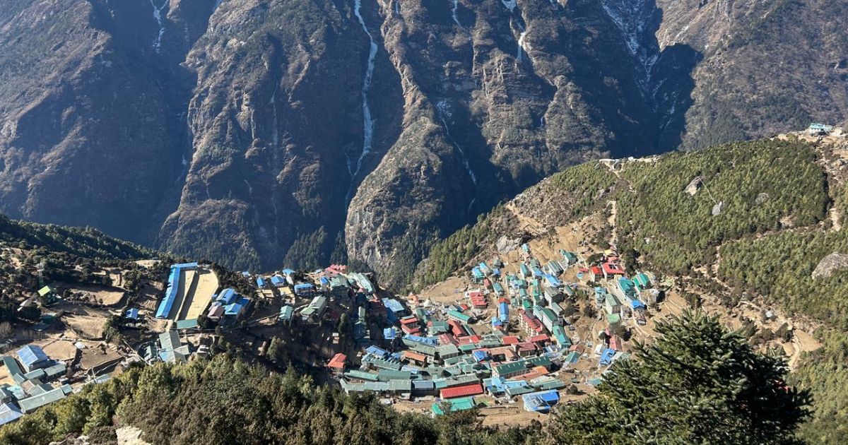
The Sherpa families who run the lodges typically come from lower villages like Pangboche, Dingboche, or Namche. They migrate to Lobuche during trekking seasons and return to their home villages when business slows. Consequently, this seasonal movement means the village lacks the community feel found in established settlements like Pheriche village or Tengboche.
Seasonal population pattern:
Spring (March-May): Lodge owners arrive, full staffing
Summer (June-August): Minimal staff, few trekkers
Autumn (September-November): Peak activity, maximum population
Winter (December-February): Most lodges close, skeleton crews only
The trekking and mountaineering economy defines everything at Lobuche. Lodge income, porter wages, and supply transport all depend on visitor flow. During good seasons, lodge owners can earn substantial income, but operating costs remain high due to supply transport and harsh conditions.
Lobuche also serves as a base camp staging area for climbers attempting Lobuche East Peak and Lobuche West Peak. Therefore, climbing groups set up tents nearby, and you may see expeditions preparing equipment or acclimatising before summit pushes. This makes Lobuche a popular village for mountaineering preparations.
The environment near the Everest region presents relentless challenges. Temperatures rarely rise above freezing, winds frequently exceed 40-50 km/h, and the landscape consists of barren rock and glacial debris. No trees grow at this elevation, and the thin air makes every physical task more difficult.
Water comes from glacial melt or snowmelt, collected and stored in tanks. During winter, water sources freeze, forcing lodge operators to melt snow or ice. Sanitation remains basic, with pit toilets located outside main buildings. Waste management follows Leave No Trace principles, but the sheer volume of trekkers in Lobuche during peak season strains the system.
Environmental conditions at Lobuche:
Oxygen levels at 53% of sea level
UV radiation significantly higher than lower elevations
Extreme temperature fluctuations between day and night
Persistent wind, especially during afternoons
Minimal vegetation, mostly mosses and lichens
The harsh reality of living at this elevation becomes immediately apparent. Simple tasks like walking to the bathroom or washing your face require effort. Your appetite may decrease, sleep quality suffers, and minor headaches or fatigue are common even in well-acclimatised trekkers.
Things to See and Experience in Lobuche
Lobuche offers limited attractions compared to culturally rich villages like Namche or Tengboche, but several noteworthy sites and experiences exist nearby. The landscape itself provides the primary draw, with glacial terrain and panoramic views of Everest and surrounding peaks dominating the scenery.
The Everest Memorial at Thukla Pass sits approximately one hour below Lobuche. This site features dozens of stone cairns and monuments dedicated to climbers and Sherpas who died on Everest and nearby peaks. Names etched on plaques include famous mountaineers and local guides who lost their lives on Everest and other Himalayan giants.
The memorial carries emotional weight. Many trekkers find themselves reflecting on the risks involved in high-altitude pursuits and the sacrifices made by those who came before. Additionally, the site offers excellent views back toward Ama Dablam and forward toward Pumori and Nuptse.
The Italian Pyramid Research Centre, also called the Pyramid Laboratory Observatory, sits at 5,050 metres between Lobuche and Gorak Shep. This permanent research station, established in 1990, studies high-altitude physiology, climate change, and environmental monitoring. Furthermore, the facility operates year-round, staffed by international scientists and researchers.
Trekkers can view the distinctive pyramid-shaped building from the trail but cannot enter without prior permission. The centre contributes valuable data on high altitude health and environmental changes in the Everest region. Its presence adds a scientific dimension to the otherwise wilderness setting.
A bakery and café near upper Lobuche claims to be the "world's highest bakery", though similar claims exist for establishments in Gorak Shep. Regardless of the title's accuracy, the bakery serves fresh bread, cinnamon rolls, and pastries, a welcome treat after days of teahouse food.
The café also offers espresso-based coffee drinks, hot chocolate, and other Western-style beverages. Prices reflect the extreme logistics involved, but many trekkers willingly pay for the morale boost. Consequently, the warm indoor seating and novelty of fresh-baked goods at this elevation make it a popular stop.
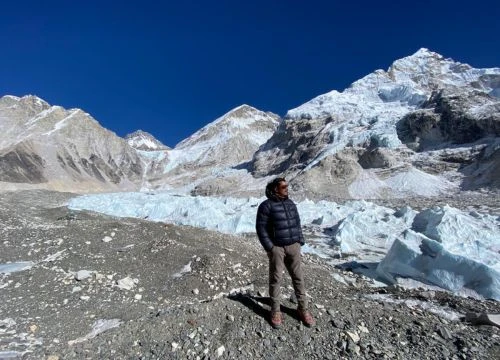
Glacier landscapes surround the village, offering photography opportunities and short exploration options. The Khumbu Glacier flows just east of Lobuche, its surface a chaotic jumble of ice towers, crevasses, and rock debris. Walking directly on the glacier without proper equipment and experience is dangerous, but views from the trail provide striking perspectives.
Nearby peaks visible from Lobuche include:
Nuptse (7,861m) to the east
Pumori (7,161m) to the northeast
Lobuche East Peak (6,119m) to the southeast
Lobuche West Peak (6,145m) to the southeast
Khumbutse (6,639m) to the north
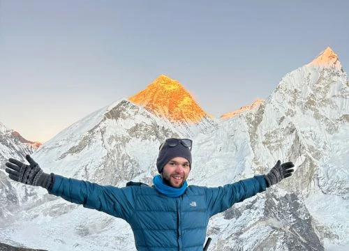
Sunrise and sunset at Lobuche offer dramatic lighting on surrounding peaks. Sunrise comes early, around 5:30-6:00 AM depending on the season, with first light hitting Nuptse and Pumori's upper slopes. The cold makes early morning photography challenging, but the golden light on ice and rock creates memorable images.
Sunset occurs around 5:00-5:30 PM, with lingering alpenglow visible on peaks well after the sun dips below the western ridges. The temperature drops rapidly once the sun sets, so warm clothing becomes essential even for brief outdoor viewing.
Lobuche Village for Acclimatisation
Lobuche plays a critical role in acclimatisation strategy for anyone heading to Everest Base Camp or climbing higher peaks. The village altitude sits at the threshold where your body must fully adapt to reduced oxygen levels before attempting further ascent. Therefore, proper acclimatisation at Lobuche significantly reduces the risk of altitude sickness and increases your chances of completing the trek successfully.
Most trekkers arrive at Lobuche after spending at least one acclimatisation day in Namche Bazaar and another in Dingboche. This gradual progression allows your body to produce additional red blood cells and adjust to thinner air. However, arriving at 4,940 metres still represents a substantial jump, especially if you hiked directly from Dingboche (4,410 m) in a single day.
Day 3: Day of acclimatisation in Namche (hike to Khumjung or the Everest View Hotel)
Day 4-5: Namche to Tengboche to Dingboche
Day 6: Acclimatisation day in Dingboche (hike to Nangkartshang Peak or Chhukung)
Day 7: Dingboche to Lobuche
This schedule follows the principle of "climb high, sleep low", allowing your body to experience higher altitudes during day hikes while returning to lower elevations for sleep. By the time you reach Lobuche village, you should have already spent several nights above 3,000 metres and taken short hikes above 4,500 metres.
The most effective acclimatisation strategy at Lobuche involves spending one full night, then continuing to Gorak Shep the following day. Some trekkers choose to spend an additional night, especially if experiencing mild symptoms like headache, reduced appetite, or poor sleep. An extra rest day allows your body more time to adapt and can make the difference between completing the trek or being forced to descend.
Short acclimatisation hikes from Lobuche provide additional altitude exposure without committing to the full push toward Gorak Shep. These hikes help your body adjust while keeping you close to Lobuche if symptoms worsen.
Acclimatisation hike options:
Hike toward Lobuche East base camp (1-2 hours up, same return)
Walk partway toward Gorak Shep and return (2-3 hours round trip)
Climb to a nearby ridge for views (1-2 hours round trip)
These short excursions elevate your heart rate, increase breathing, and expose you to higher altitudes without overnight commitment. The key is returning to Lobuche to sleep, maintaining the "climb high, sleep low" principle.
Recognising altitude sickness symptoms becomes crucial at this elevation. Acute Mountain Sickness (AMS) can develop quickly, and ignoring early warning signs can lead to life-threatening conditions like High Altitude Pulmonary Edema (HAPE) or High Altitude Cerebral Edema (HACE).
Common altitude sickness symptoms:
Persistent headache that worsens with exertion
Nausea, vomiting, or loss of appetite
Dizziness or lightheadedness
Fatigue beyond normal exertion
Difficulty sleeping despite exhaustion
Shortness of breath at rest
If you experience mild symptoms, rest, hydrate, and avoid further ascent until they resolve. If symptoms worsen or new severe symptoms appear, descend immediately. Descending even 300-500 metres can provide significant relief. Lobuche village is generally safe for most properly acclimatised trekkers, but individual responses to altitude vary.
To prevent altitude sickness, follow these practices:
Ascend gradually, following recommended itineraries
Stay hydrated (3-4 litres of water daily)
Avoid alcohol and sleeping medications
Eat regular meals even if appetite decreases
Consider Diamox (acetazolamide) after consulting a doctor(Only for emergency case).
Listen to your body and communicate symptoms to your guide
Lobuche marks the point where turning back becomes more common. If you feel unwell, descending is the safest choice. The mountains will always be there for another attempt.
Namche Bazaar
Trekking Beyond Lobuche
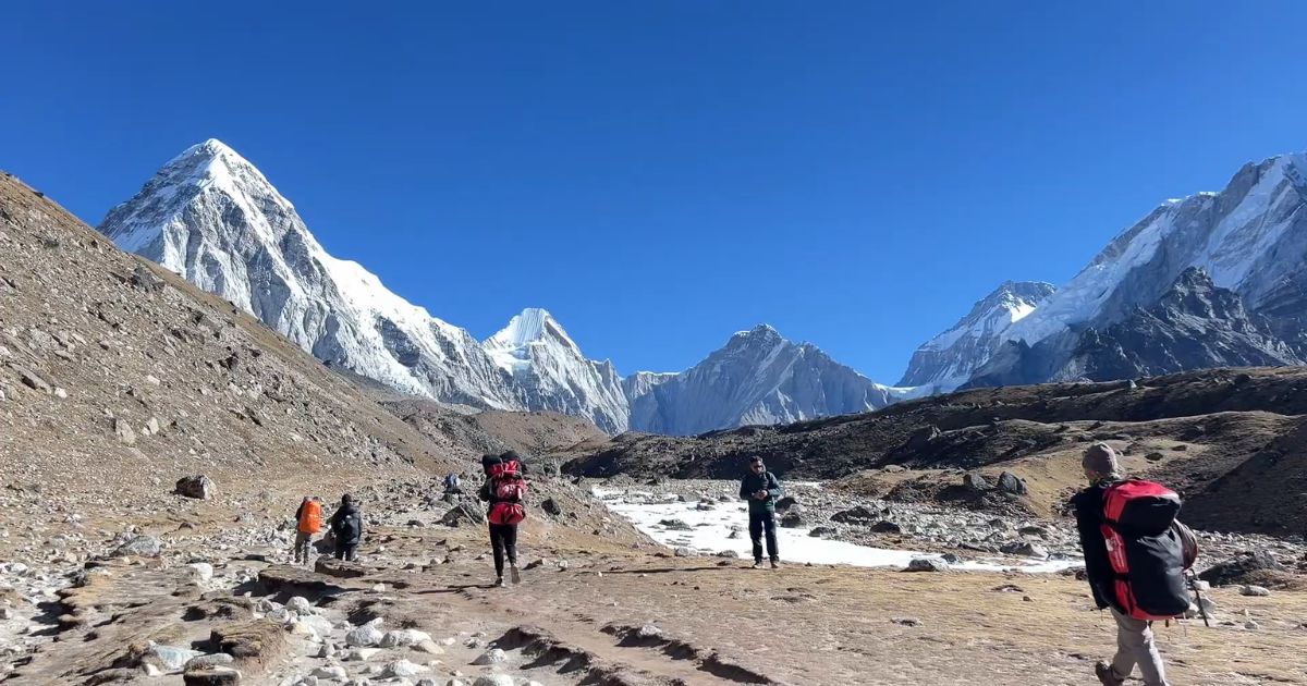
From Lobuche, the trail continues northeast toward Gorak Shep, the last settlement before Everest Base Camp. The Lobuche to Gorak Shep section covers approximately 3.4 kilometres and takes 2-3 hours, depending on pace and conditions. This section crosses rocky moraine terrain alongside the Khumbu Glacier, with minimal elevation gain but increasing exposure to wind and cold.
Trail characteristics from Lobuche to Gorak Shep:
Distance: 3.4 km
Elevation gain: approximately 224 meters (4,940m to 5,164m)
Terrain: Rocky glacial moraine, some icy sections
Difficulty: Moderate; altitude makes it feel harder
Conditions: Exposed to wind, little shelter
The path follows the western side of the Khumbu Glacier, winding through boulder fields and crossing small streams fed by glacial melt. During winter, ice covers sections of the trail, requiring careful footing. Therefore, trekking poles become especially useful for balance and stability.
Gorak Shep sits in a dry lakebed surrounded by barren mountains. The village contains several basic lodges, similar in standard to Lobuche but even more exposed to wind. Most trekkers arrive, drop their packs, and immediately continue to either Everest Base Camp or Kala Patthar before settling in for the night.
Everest Base Camp lies approximately 3.5 kilometres northeast of Gorak Shep, requiring 2-3 hours of walking across glacial moraine. The trail follows the Khumbu Glacier's edge, offering close views of ice seracs and crevasses. Lobuche to Everest Base Camp via Gorak Shep totals roughly 8.5 kilometres and 5-6 hours of walking time.
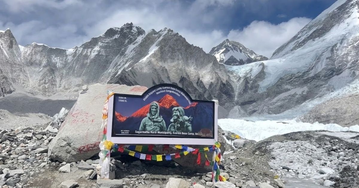
Base camp itself consists of tents and expedition infrastructure during climbing season (March-May and September-November). Outside these periods, the site appears empty except for prayer flags and stone markers. The iconic "Everest Base…" sign provides a photo opportunity, though the main Everest peak remains hidden behind surrounding ridges.
Location
Distance from Lobuche
Walking Time
Gorak Shep
3.4 km northeast
2-3 hours
Everest Base Camp
~8.5 km northeast
5-6 hours (via Gorak Shep)
Kala Patthar
5.2 km northeast
4-5 hours (via Gorak Shep)
Many trekkers choose to hike to Everest Base Camp from Gorak Shep in the afternoon, return to sleep at Gorak Shep, then wake early the next morning to climb Kala Patthar before descending back toward Lobuche or lower.
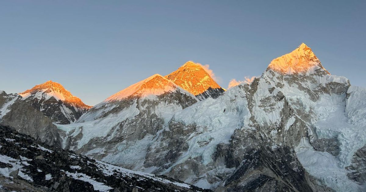
Kala Patthar (5,545 m) offers the best viewpoint accessible to trekkers for seeing Mount Everest's summit. The climb from Gorak Shep takes 2-3 hours, gaining approximately 400 metres of elevation. Most trekkers start before dawn to catch the sunrise illuminating Everest, Nuptse, and Pumori.
Kala Patthar route timing:
Departure from Gorak Shep: 4:00-5:00 AM
Sunrise: 5:30-6:00 AM (seasonal variation)
Time at summit: 1 hr to 1:30 minutes
Descent to Gorak Shep: 1-2 hours
The trail to Everest via Kala Patthar involves steep switchbacks on loose scree, making footing difficult in darkness. Headlamps are essential. The thin air makes each step laboured, and the cold before sunrise bites through even good clothing. However, the sunrise view from the summit ranks among the most spectacular mountain panoramas anywhere on Earth.
Trail difficulty beyond Lobuche increases primarily due to altitude rather than technical challenges. The paths remain well-marked and require no climbing or scrambling. However, the reduced oxygen makes exertion feel significantly harder. Tasks that seem simple at sea level, like climbing a small hill or walking at a steady pace, become exhausting.
Common challenges beyond Lobuche:
Extreme cold, especially in morning and evening
High winds creating wind chill and blowing dust
Reduced oxygen affecting energy and endurance
Potential for snow or ice on trails
Limited shelter or escape options if weather worsens
Weather can change rapidly. Clear mornings often give way to afternoon clouds, and winds intensify as the day progresses. Carrying proper gear, including windproof layers, an insulated jacket, gloves, and a hat, remains essential even during favourable seasons.
Everest Base Camp
Lobuche Peak Climbing Overview
Lobuche Peak refers to two distinct summits, Lobuche East (6,119 m) and Lobuche West (6,145 m), separated by a long ridge. These peaks rise directly above the village, making Lobuche the natural staging point for climbing attempts. Lobuche East sees far more ascents, as it is classified as a "trekking peak" by the Nepal Mountaineering Association, while Lobuche West Peak remains a restricted technical peak requiring special permission.
Feature
Lobuche East
Lobuche West
Elevation
6,119 m
6,145 m
Classification
NMA Trekking Peak
Expedition Peak
Permit
NMA Permit (~USD 250-400)
Special Permission Required
Technical Difficulty
Moderate to Difficult
Very Difficult
Climbing Season
Spring & Autumn
Rarely Climbed
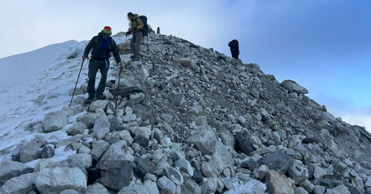
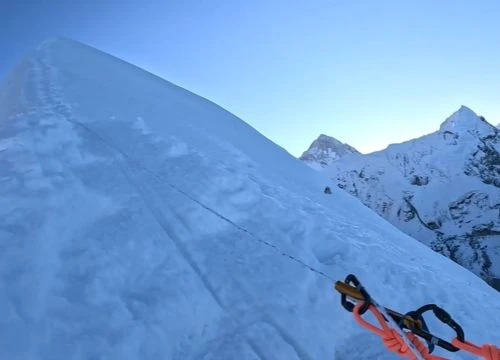
Lobuche East suits experienced trekkers looking to attempt their first 6,000-metre peak. However, calling it a "trekking peak" misleads beginners. The route involves glacier travel, fixed ropes, steep ice sections, and significant avalanche risk. Consequently, previous mountaineering experience, comfort with crampons and ice axes, and good physical conditioning are necessary.
The climb typically takes 2-3 days from Lobuche village. Groups establish a high camp at approximately 5,400 metres, then summit early the next morning before descending back to Lobuche or lower. The ascent requires crossing crevassed glaciers, climbing steep snow and ice slopes up to 45-50 degrees, and navigating exposed ridges.
Technical difficulty breakdown:
Glacier travel with crevasse danger
Fixed rope sections on steep terrain
Ice climbing sections requiring crampons and ice axe
High-altitude challenges above 6,000 meters
Summit ridge with exposure on both sides
Climbers need personal gear, including a harness, crampons, an ice axe, a helmet, and warm clothing suitable for summit attempts. Most groups hire professional guides who provide technical equipment like ropes, carabiners, and snow stakes. Moreover, the Lobuche far East section presents particularly challenging technical climbing.
Additionally, climbers must pay NMA membership fees and garbage deposit fees. Climbing permits cannot be obtained independently; you must book through a registered trekking agency in Nepal.
Typical itineraries combining the Everest Base Camp trek with Lobuche Peak climbing require 18-22 days total, including travel days to and from Kathmandu. The schedule includes proper acclimatisation, a trek to base camp, a summit attempt, and a return.
Sample combined itinerary:
Days 1-7:Trek from Lukla to Lobuche (standard EBC trek route)
Day 8: Rest and preparation at Lobuche
Day 9:Trek to Lobuche High Camp or peak base camp (5,400m)
Day 10: Summit attempt and return to Lobuche or lower
Days 11-14: Return trek to Lukla
This schedule can be adjusted based on weather, group fitness, and individual acclimatisation needs. Contingency days should be built in for weather delays or additional rest.
Summit attempts typically begin around 1:00-2:00 AM, aiming to reach the top by 8:00-9:00 AM before afternoon weather deteriorates. The climb takes 6-8 hours from high camp, with descent requiring 3-4 hours. Success rates vary significantly based on weather, conditions, and climber experience, typically ranging from 40% to 70%.
Safety considerations for climbing:
Avalanche risk increases after snowfall
Crevasse falls pose constant danger
Altitude sickness becomes more severe above 6,000m
Frostbite risk due to extreme cold and wind
Summit fever can lead to poor decision-making
Guides make final decisions about summit attempts based on weather forecasts, snow conditions, and team fitness. Turning back before the summit, while disappointing, often represents the safest choice. The mountain will always be there for another attempt.
Travellers Walking on Everest Base camp route
Practical Travel Tips for Lobuche Village
Packing properly for Lobuche makes the difference between manageable discomfort and genuine suffering. The high altitude and extreme cold demand specific gear beyond what might suffice at lower elevations. Your pack should balance warmth, weight, and functionality.
Layering becomes critical. Temperatures fluctuate dramatically between morning cold, midday sun exposure, and evening freezing. The ability to add or remove layers quickly keeps you comfortable and prevents overheating or dangerous chilling.
Effective layering strategy:
Base layer: Moisture-wicking synthetic or merino wool
Mid layer: Fleece or light down for insulation
Outer layer: Windproof, waterproof shell
Insulated layer: Down jacket for stops and evenings
Start the day cold rather than warm. You will generate heat while walking, and beginning too warm leads to sweating, which dampens clothing and creates dangerous chilling when you stop. Adjust layers frequently based on exertion, sun exposure, and wind.
Budgeting for Lobuche requires accounting for inflated prices at high altitude. Everything costs more due to transport difficulties and limited supply. Daily expenses typically run higher than anticipated, especially if you want hot showers, device charging, or treats from the bakery.
Expense
Cost (NPR)
Cost (USD)
Room
500-1,000
4-8
Meals (3 per day)
2,000-3,000
15-25
Snacks and drinks
500-1,000
4-8
Hot shower
500-700
4-6
Battery charging
300-500
2-4
Wifi access
500-1,000
4-8
Total
4,300-7,200
33-59
Budget approximately USD 40-60 per day at Lobuche, more if you want additional services or comfort items. Prices increase during peak season when demand exceeds supply.
Cash remains king at Lobuche. No ATMs exist above Namche Bazaar, and electronic payment systems do not function reliably at this elevation. Carry sufficient Nepali rupees in small denominations for daily expenses, tips for guides and porters, and emergency contingencies.
Cash planning:
Withdraw maximum cash in Kathmandu or Namche
Carry small bills (100 and 500 rupee notes)
Budget extra 20-30% for unexpected expenses
Keep emergency cash separate from daily money
Consider USD as backup (some lodges accept dollars)
Credit cards and digital payment apps do not work. Plan your cash needs carefully before leaving Namche, as returning to withdraw more money wastes valuable trekking days and disrupts acclimatisation schedules.
Connectivity at Lobuche remains limited and unreliable. Mobile signals from Ncell and NTC work sporadically, though coverage drops frequently. Wifi exists in lodges but connects slowly, drops regularly and costs extra. Data packages rarely provide enough bandwidth for video calls or heavy internet use.
Connectivity reality:
Mobile signal: Spotty, best near lodge buildings
Wifi speed: 0.5-2 Mbps on good days
Cost: NPR 500-1,000 for limited data
Best use: Text messages, emails, light browsing
Forget about: Video calls, streaming, large downloads
Prepare for limited communication. Download offline maps, trek guides, and entertainment before leaving Kathmandu. Inform family and friends that communication will be sporadic. Embrace the digital detox as part of the high-altitude village experience.
Common mistakes trekkers make at Lobuche:
Ascending too quickly without proper acclimatisation
Underpacking warm clothing to save weight
Relying on lodge blankets instead of bringing a quality sleeping bag
Not drinking enough water due to cold reducing thirst sensation
Skipping meals because of reduced appetite
Pushing through symptoms instead of resting or descending
Expecting comfort levels similar to lower villages
Forgetting to charge devices at lower elevations
Not carrying emergency cash reserves
Underestimating how cold it actually gets at night
Avoiding these mistakes significantly improves your Lobuche experience. Preparation, realistic expectations, and willingness to adapt to harsh conditions make the difference between a successful trek and a difficult struggle.
Sample Trekking Itineraries Including Lobuche
Standard Everest Base Camp trek itineraries typically allocate 12-14 days from Kathmandu and back, including flights to and from Lukla. This schedule provides adequate acclimatisation for most healthy trekkers while maintaining a reasonable pace. Lobuche appears on Day 8 or 9, depending on rest days. These represent some of the most common tours in Nepal focused on the Everest trekking route.
Day
Route
Elevation
Duration
1
Fly Kathmandu to Lukla, trek to Phakding
2,610 m
3-4 hours
2
Phakding to Namche Bazaar
3,440 m
5-6 hours
3
Acclimatisation day in Namche
3,440 m
Rest or day hike
4
Namche to Tengboche
3,860 m
5-6 hours
5
Tengboche to Dingboche
4,410 m
5-6 hours
6
Acclimatisation day in Dingboche
4,410 m
Rest or day hike
7
Dingboche to Lobuche
4,940 m
5-6 hours
8
Lobuche to Gorak Shep, hike to EBC, return
5,164 m
7-8 hours
9
Climb Kala Patthar, descend to Pheriche
4,371 m
7-8 hours
10
Pheriche to Namche Bazaar
3,440 m
6-7 hours
11
Namche to Lukla
2,860 m
6-7 hours
12
Fly Lukla to Kathmandu
-
30 min flight
This itinerary suits moderately fit trekkers with limited time. However, it pushes relatively hard on Days 8-9, combining overnight in Lobuche, hiking to Everest Base Camp, and climbing Kala Patthar within a compressed timeframe.
Slow-paced itineraries add extra acclimatisation days, reducing daily exertion and improving success rates. This approach particularly benefits older trekkers, those with previous altitude difficulties, or anyone preferring a more relaxed pace. Additionally, additional rest days allow better altitude adaptation and reduce altitude sickness risk.
Trekkers combining the classic Everest base camp route with Lobuche Peak climbing require 18-22 days total. This extended itinerary includes all standard acclimatisation, the full trek to Everest Base Camp, technical climbing preparation, summit attempt, and return.
This itinerary builds in contingency time for weather delays, which frequently impact summit attempts. Flexibility remains essential, as conditions at 6,000+ metres can change rapidly, forcing schedule adjustments.
Lukla Airport most popular gateway to Mt. Everest.
Is Lobuche Village, Nepal, Right for Your Trek?
Lobuche village, Nepal, represents the final test before Everest Base Camp, where altitude, cold, and harsh conditions separate prepared trekkers from those who underestimated the challenge. The village offers no luxury, limited comfort, and demands resilience. Yet it remains an essential stop for safe altitude progression and proper preparation for the heights beyond.
This village in Nepal's Everest region suits trekkers who understand the realities of Himalayan conditions and come prepared for discomfort, cold, and physical challenge. It rewards those who acclimatise properly, pack appropriately, and maintain realistic expectations. For experienced hikers, mountaineers planning Lobuche Peak attempts, and determined first-timers, Lobuche delivers an authentic high altitude experience unavailable at lower, more comfortable villages.
Ultimately, Lobuche Village functions as a checkpoint on the way to Everest Base Camp, a necessary pause where your body adapts and your resolve solidifies. Whether you stay in Lobuche for one night or two, the experience shapes your understanding of what it means to trek at extreme elevations in one of the world’s most demanding high altitude mountain environments. For route guidance, acclimatisation planning, or logistics support, contact Nepal Everest Base Camp Co. to trek this section of the Khumbu region safely and with confidence.
Mountain see from lobuche
Lobuche Village, Nepal: FAQs
How High Is Lobuche Village?
Lobuche sits at 4,940 metres (16,207 feet) above sea level. This elevation places it in the high altitude zone where oxygen levels drop to approximately 53% of sea level.
Can You See Mount Everest from Lobuche?
Mount Everest's summit is not visible directly from Lobuche village due to intervening ridges and peaks. However, surrounding peaks like Nuptse, Pumori, and Ama Dablam provide spectacular views.
How Cold Does It Get in Lobuche at Night?
Nighttime temperatures range from -10°C to -20°C during main trekking seasons (spring and autumn). Winter temperatures drop below -25°C, while summer nights remain slightly warmer at -5°C to -10°C.
Is Lobuche Safe for First-Time High-Altitude Trekkers?
Lobuche village is generally safe for properly acclimatised first-time high-altitude trekkers who follow recommended itineraries with gradual ascent. However, individual responses to altitude vary, so monitoring symptoms remains critical.
How Many Nights Should You Stay in Lobuche?
Most trekkers stay one night at Lobuche before continuing to Gorak Shep and Everest Base Camp. A second night at Lobuche is optional, but it improves acclimatisation and reduces altitude sickness risk, especially for trekkers with mild altitude symptoms.
What Is the Best Time to Visit Lobuche Village?
The best time to visit Lobuche is during spring (March-May) or autumn (September-November). These seasons offer stable weather in Lobuche, clear skies, and safer trekking conditions compared to monsoon or winter months.
What Are the Most Frequently Asked Questions About Lobuche?
The most frequently asked questions about Lobuche concern altitude levels, accommodation quality, weather in Lobuche, acclimatisation strategies, and climbing opportunities on Lobuche Peak. This guide addresses all major planning considerations for your visit to Lobuche.
Blending digital strategy with mountain passion, I help adventurers find their way to the Himalayas online. With hands-on experience in Nepal’s trekking trails and a role at Nepal Everest Base Camp Trekking Co., Thamel, I combine SEO expertise with true trail insight.