Chukhung Ri is the viewpoint experienced trekkers quietly rate above Kala Patthar, and once you understand why, it is hard to argue with them. Kala Patthar is the one everyone knows, the classic shot in every guidebook and trip report, a silhouette against a pale dawn sky. But above the village of Chhukung, in the Imja Valley, there is a quieter ridge that gets a fraction of the foot traffic and, for many, a better view. That ridge is Chukhung Ri, and it earns its reputation on its own terms.
Nepal has no shortage of high viewpoints, and the Khumbu alone offers several worth the climb. Each one gives you something different, though: a different angle, a different set of peaks, a different kind of silence. Chukhung Ri sits at the eastern end of the Everest Base Camp trek corridor, past Dingboche, in a valley most trekkers only pass through on their way to somewhere else. That is part of why the peak gets overlooked and part of why it is worth understanding properly before you go.
This guide covers Chukhung Ri in full, its geography, altitude, mountain views, terrain, the atmosphere in Chukhung Village below it, its role in acclimatisation, how it stacks up against other Khumbu viewpoints, and what conditions on the mountain are actually like. By the end, you will know exactly what kind of place this is and whether it belongs on your itinerary with Nepal Everest Base Camp Pvt Ltd.
1. Where Is Chukhung Ri?
It sits in the Khumbu region of Nepal, within the Solukhumbu District of Koshi Province. It rises at the head of the Imja Valley, above the small settlement of Chukhung (also spelt Chukkung), at an elevation of 5,550m above sea level.
Getting to Chukhung takes roughly a week on foot. Trekkers fly from Kathmandu to Lukla, then walk through Phakding, Monjo, Namche, Tengboche, Pangboche, and Dingboche before the final push. That last stretch, from Dingboche to Chukhung, is a short one, about two hours, and it's where the valley starts to feel remote. The Imja Khola runs along the valley floor beneath the peak, fed by glacial melt off the surrounding ridgelines.
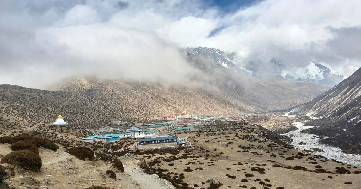
Dingboche sits about two hours west of Chukhung and is usually where trekkers spend a rest day before pushing higher.
Lobuche lies to the northwest, along the main Everest Base Camp route.
Another route crosses the Khomla Pass and joins the trail to Lobuche as well.
Island Peak base camp sits close by to the east, making Chukhung Ri a natural acclimatisation objective for climbers heading to that trekking peak.
2. The Meaning and Spelling of Chukhung Ri
The name confuses people before they even arrive. You will find it written as Chukhung Ri, Chhukung Ri, and occasionally Chukkung on older maps. All refer to the same peak.
"Ri" is a Tibetan and Sherpa word meaning "peak" or "mountain". You see it across the Himalaya: Gokyo Ri, Nangkartshang Ri, and Pokalde Ri.
"Chukhung" refers to the valley and the settlement below the peak. The spelling varies by map source, trekking agency, and era of publication.
For practical purposes, Chukhung Ri is the most widely used spelling in current English-language Nepali trekking literature.
There is no standard Nepali romanization rule that has been applied consistently across mountain names in the Khumbu, so variation is normal and should not cause concern when planning a route.
3. What Chukhung Ri Looks Like
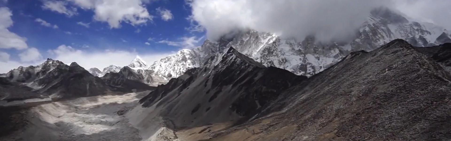
Chukhung Ri is not a dramatic, knife-edged peak. It is a broad, high ridge with two distinct high points: a lower summit at around 5,350m and the true summit at 5,550m. Many trekkers reach the lower summit and stop there. The views from both are significant.
The Terrain
Years of foot activity have eroded the grassy moraine on the lower slopes above Chukhung hamlet into broad paths.
Above roughly 5,000m, the terrain shifts into scree and rocky terrain, loose underfoot and requiring care with each step.
Cairns and cairns marking the route are visible along the upper ridge, useful in poor visibility.
The Nup Glacier and its lateral moraine sit to the west, visible from the upper slopes.
The Imja Khola cuts the valley floor far below, a thin silver line between dark moraine walls.
The ridge itself is wide enough to walk comfortably once you reach it, though wind exposure increases sharply near the true summit. The upper section is a steep uphill climb over rocky terrain and loose stone, and it requires steady footing. There are no ropes, no technical sections, and no equipment beyond good boots and warm layers.
4. The Views From Chukhung Ri
This is the section that earns the peak its reputation. The panorama from the summit is one of the most complete in the entire Khumbu, and it is a different view from what you get at Kala Patthar or Gokyo Ri.
Mountains Visible From the Summit
Mountain
Elevation
Notes
Ama Dablam
6,812m
Close and dominant to the southwest
Lhotse
8,516m
Fills the western skyline
Nuptse
7,861m
Ridge visible to the northwest
Makalu
8,485m
Clear to the east on good days
Baruntse
7,129m
Visible to the southeast
Island Peak (Imja Tse)
6,189m
Prominent to the east
Thamserku
6,608m
Visible to the south
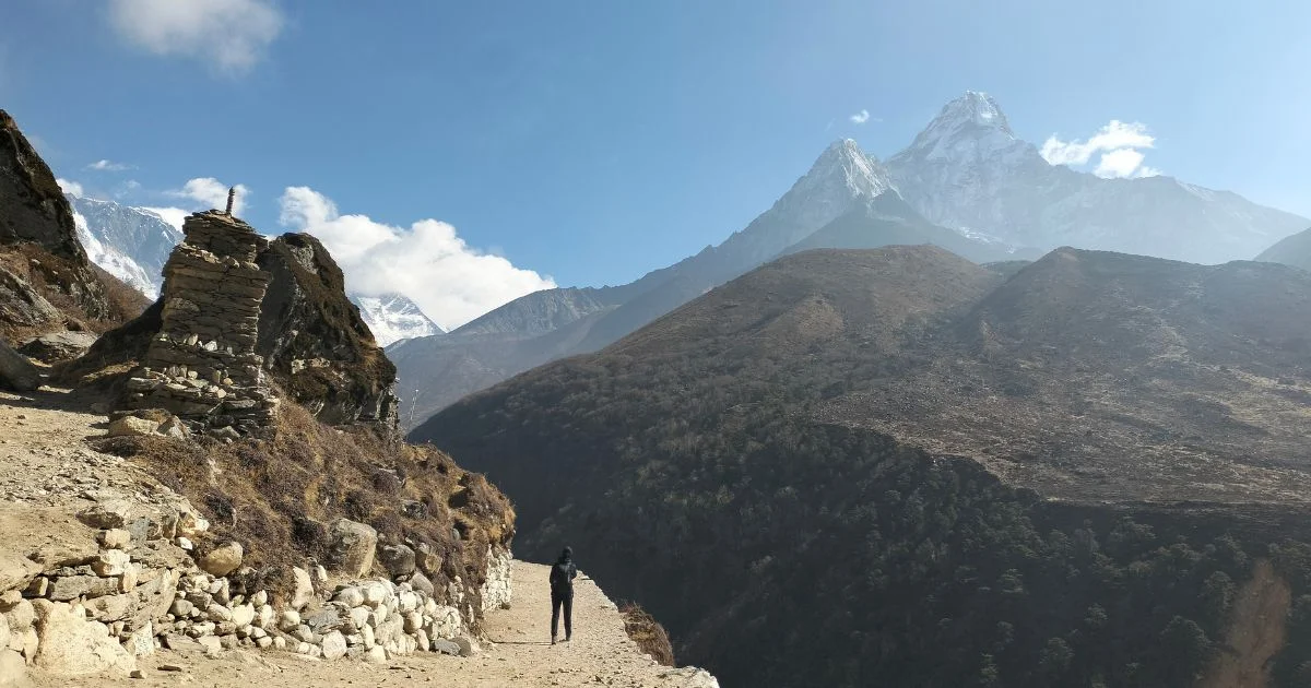
Ama Dablam and Lhotse dominate the view from the summit in a way that few other viewpoints match. Ama Dablam in particular looks extraordinary from here, its southwest ridge angled toward you in a way that shows its full bulk. Lhotse fills the western horizon, vast and close.
Why You Cannot Clearly See Everest From Chukhung Ri
This is worth addressing directly. Mount Everest is visible from Chukhung Ri, but only partially. Lhotse's south face blocks the primary view. If you want to see Everest clearly, Kala Patthar remains the better option for that specific purpose. But if your goal is a broader Himalayan mountain panorama, particularly of the eastern Khumbu peaks, Chukhung Ri is arguably superior.
Sunrise and Photography
Early morning light hits the western faces of Ama Dablam and Lhotse directly. The first hour after sunrise is the best window for photography.
Cloud builds from the south and east through the afternoon, often reducing visibility by midday.
Start before dawn if photography is a priority.
5. Chukhung Village and the Atmosphere Around the Peak
Chukhung is a small Sherpa village at roughly 4,730m, with a handful of lodge buildings that open during the main trekking seasons. It is quieter than Dingboche and considerably quieter than the main Everest Base Camp route.
Meals in the lodges follow the standard Khumbu pattern: dal bhat, noodle soups, eggs, and hot drinks. A basic meal costs around 800 to 1,200 rupees depending on the lodge.
Yak trains pass through regularly, carrying supplies up the valley. In the morning, you will often hear them before you see them.
The hospitality in Chukhung is warm and direct. Lodge owners here are used to trekkers who are acclimatising or preparing for Island Peak or Imja Tse, and they understand the rhythms of altitude travel.
Sherpa culture is present in small but visible ways: prayer flags above the lodges, mani walls along the trail into the village, and the quiet efficiency of high-altitude life.
The atmosphere here is noticeably calmer than the main EBC corridor. There are fewer teahouses, fewer groups, and a stronger sense of being at the edge of something remote. That quality is part of what makes the area worth the detour.
6. Chukhung Ri and Acclimatization
It has become a standard acclimatisation hike for trekkers and climbers operating in the upper Khumbu. The reason is practical: it takes you to 5,550m and back in a single day from Chukhung, without committing to a high-altitude pass or a technical climb.
Trekkers on the Everest Base Camp trek sometimes include Chukhung Ri as a side objective from Dingboche, spending an extra day to ascend the peak before continuing toward Lobuche.
Climbers preparing for Island Peak (formally Imja Tse) use the summit of Chukhung Ri to test their response to high altitude before committing to the climb.
On the three passes trek, Chukhung Ri is a natural add-on during the Kongma La section of the route.
Altitude sickness is a real consideration here. The climb from Chukhung village at 4,730m to the summit at 5,550m is an 820m gain in a single morning. Anyone moving too fast or who has not spent enough time at lower elevations will feel it. The standard advice applies: go slowly, drink enough water, and turn back if you develop a headache that does not ease with rest.
7. Difficulty and Physical Challenge
Chukhung Ri is not technically difficult. There is no mountaineering equipment required, no glacier crossing, and no roped section. But it is a serious high-altitude climb, and underestimating it is common.
Factor
Reality
Technical difficulty
Low. No ropes or climbing gear needed.
Physical demand
Moderate to high due to altitude.
Terrain
Steep scree and loose rock above 5,000m.
Round trip from Chukhung
4 to 6 hours depending on pace.
Route description
Well-marked by cairns.
Need permits
Yes. Sagarmatha National Park entry permit required.
Most people slow down considerably on the hard uphill climb over the mid-ridge. At this altitude, a slope that would feel moderate at 2,000m feels genuinely hard. Short steps, a slow pace, and steady breathing are more effective than trying to maintain a sea-level hiking rhythm. Any hiker in good cardiovascular shape can reach the summit with proper acclimatisation, provided they respect the pace.
Mt Amadablam on the way to chukung village
8. Best Time to Visit Chukhung Ri
Conditions vary significantly by season, and choosing the right window matters more at this elevation than it does on lower trails.
Season
Conditions
March to May (Spring)
Best overall. Clear skies, stable weather, good visibility.
Poor visibility. Cloud and rain common. Not recommended.
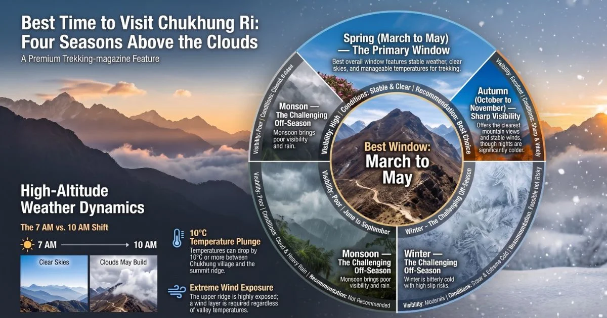
March to May is widely considered the best window, with long clear mornings and manageable temperatures. Autumn is equally good in terms of visibility and arguably more stable in terms of wind. Winter is feasible but cold, with snow making the upper scree section more difficult and the risk of slipping higher than usual.
Weather Near the Summit
Wind exposure on the upper ridge is significant. Even on a warm morning in the valley, the summit can be cold and windy.
Temperature can drop by 10°C or more between the village and the ridge.
Conditions change fast in the Khumbu. Clear skies at 7am can shift to cloud by 10am. Start early.
Infography Best time to visit chukung
9. Wildlife, Vegetation, and High-Altitude Environment
Above Dingboche, vegetation thins quickly. By the time you reach Chukhung, the landscape is open moraine, scrub juniper along sheltered gullies, and sparse alpine grass on the lower slopes.
Himalayan snowcocks are sometimes heard on the upper ridges, though rarely seen.
Lammergeiers (bearded vultures) are seen occasionally riding thermals above the Imja Valley.
Snow leopard territory extends through this part of Sagarmatha National Park, though sightings are rare.
The high-altitude environment here is fragile. Trail widening, waste from lodges, and increasing foot traffic have put pressure on the upper slopes. The Nepali government and park authorities have introduced waste regulations in recent years, and trekkers are expected to carry out what they bring in above the village.
10. Chukhung Ri Compared to Other Everest Region Viewpoints
This is the comparison most trekkers want before deciding where to spend a day.
Chukhung Ri vs Kala Patthar: If you want the classic postcard shot, Kala Patthar wins; it gives you the cleaner Mount Everest view. Chukhung Ri trades that for a wider mountain panorama, fewer people on the trail, and more room to breathe. Trip reports keep coming back to the same point too: the Ama Dablam view from Chukhung Ri is more dramatic than from any other standard viewpoint in the Khumbu.
Chukhung Ri vs Gokyo Ri: The short answer is that they show you different mountains. Gokyo Ri sits in the western Khumbu on a separate route altogether and rewards you with a broader Everest and MountCho Oyuview, though you'll share the trail with more trekkers. Chukhung Ri sits off on its own and leans east, toward peaks Gokyo Ri doesn't really show you.
Chukhung Ri vs Nangkartshang: Pick Nangkartshang if you want something easier. It's lower, gentler, and works well as an acclimatisation walk from Dingboche. Chukhung Ri asks more of you; it's higher and tougher going, but if you only have time for one, it gives you more in return.
11. Things Visitors Often Underestimate
Many people arrive at Chukhung without fully accounting for what the summit push actually involves. These are the factors that trip reports and guides consistently flag.
Altitude gain from the village: The 820m climb from Chukhung to the summit feels much larger than it reads on paper. Give yourself more time than you anticipate.
Sun exposure: At this elevation, UV intensity is high. Sun cream, sunglasses, and lip protection are not optional.
Pace management: The summit push is frequently more difficult than anticipated for hikers who have travelled quickly to reach Chukhung. Two nights at Dingboche before attempting it makes a noticeable difference.
Wind on the upper ridge: Even a light breeze at lower elevation can translate to a strong, cutting wind at 5,550 m. Regardless of the temperature in the morning, bring a wind layer.
Permits: You need two permits for this trek, the Sagarmatha National Park entry permit and the Khumbu Pasang Lhamu Rural Municipality entry permit. These are arranged in Kathmandu or at the park entrance. There is no permit office at Chukhung.
12. Chukhung Ri in the Larger Everest Region
It sits at a junction point within the upper Khumbu, and understanding its position in the wider region of Nepal helps explain why it matters to more than just viewpoint seekers.
Kongma La (5,535m) is the high pass that connects Chukhung to Lobuche. Trekkers crossing Kongma La on the Three Passes Trek often include Chukhung Ri as a rest-day objective.
Island Peak (also known as Imja Tse) base camp is a short walk from Chukhung. Many mountaineer teams spend several days in the village before their summit bid, and Chukhung Ri is standard preparation.
The Imja Valley itself is becoming more significant in Nepal trekking discussion because of the Imja Khola glacial lake above the valley, one of the fastest-growing glacial lakes in the region.
Experienced trekkers consistently rate this corner of the Khumbu as one of the less-crowded and more atmospheric parts of the Everest Base Camp area.
Chukhung Ri: Final Thoughts
Chukhung Ri is not a side hike. It is a proper high-altitude climb that rewards preparation, patience, and an early start. The mountain views it gives you, the angle on Ama Dablam, the widespread eastern Khumbu peaks, and the quiet of the Imja Valley below make it a genuinely distinctive experience within the Everest region.
For trekkers willing to go a step beyond the main Everest Base Camp route, the village of Chhukung and the ridge above it offer something the busier trails rarely do. The scale feels real here. The peaks are close, the air is thin, and the landscape is less managed than the areas further down the valley toward Namche and Tengboche.
This is the kind of place that stays with you precisely because it does not feel packaged. The summit is earned, the panorama is genuine, and the Khumbu Valley you descend into afterward is quiet enough that you can actually take it in. That combination is rarer in the Himalayas than people expect. If you are planning to experience Chukhung Ri, contact Nepal Everest Base Camp Pvt Ltd to plan your trek with experienced local guides.
Dingboche village
Chukhung Ri: FAQs
How High Is Chukhung Ri?
It stands at 5,550m above sea level, making it one of the higher non-technical viewpoints in the Khumbu region of Nepal. Most trekkers reach this elevation in a single morning push from Chukhung village at 4,730m, an ascent of around 820m.
Is Chukhung Ri harder than Kala Patthar?
Both peaks are at a similar level of physical difficulty, but Chukhung Ri involves steeper and looser terrain on the upper section. Kala Patthar has a more established trail with better foot placement, while the scree and rocky terrain on Chukhung Ri demands more careful footwork.
Can Beginners Visit Chukhung Ri?
Yes, provided they have spent enough time acclimatising at lower elevations and are in reasonable cardiovascular shape. The climb requires no technical mountaineering skills, but the altitude and steep upper slope mean that anyone moving too fast will struggle regardless of fitness level.
Which Mountains Can Be Seen From Chukhung Ri?
The summit gives clear views of Ama Dablam, MountLhotse, Nuptse, Makalu, Baruntse, Imja Tse, and Thamserku. Mount Everest is partially visible, but Lhotse blocks the full view. For the best Everest sightline, Kala Patthar remains the stronger option.
What Is the Best Season to Visit Chukhung Ri?
March to May and October to November are both excellent, offering stable weather and clear morning visibility. Spring tends to give slightly warmer temperatures, while autumn offers sharper air and often the best photography light on the western faces of the surrounding peaks.
Blending digital strategy with mountain passion, I help adventurers find their way to the Himalayas online. With hands-on experience in Nepal’s trekking trails and a role at Nepal Everest Base Camp Trekking Co., Thamel, I combine SEO expertise with true trail insight.